Palmetto Bay, Florida
Palmetto Bay, Florida | |
|---|---|
| Village of Palmetto Bay | |
 | |
| Nickname: Village of Parks | |
 Location in Miami-Dade and the state of Florida. | |
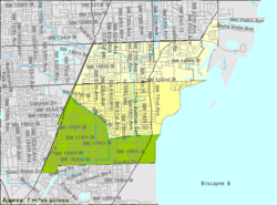
 U.S. Census Bureau map showing village boundaries | |
| Coordinates: 25°37′37.87″N 80°19′14.53″W / 25.6271861°N 80.3207028°W | |
| Country | |
| State | |
| County | |
| Incorporated | September 10, 2002 |
| Government | |
| • Type | Mayor-Council |
| • Mayor | Karyn Cunningham |
| • Vice Mayor | Mark Merwitzer |
| • Councilmembers | Patrick Fiore, Steve Cody, and Marsha Matson |
| • Village Manager | Nick Marano |
| • Village Clerk | Missy Arocha |
| Area | |
• Total | 8.44 sq mi (21.86 km2) |
| • Land | 8.29 sq mi (21.46 km2) |
| • Water | 0.16 sq mi (0.41 km2) 0.44% |
| Population | |
• Total | 24,439 |
| • Density | 2,949.79/sq mi (1,138.96/km2) |
| Time zone | UTC-5 (EST) |
| • Summer (DST) | UTC-4 (EDT) |
| ZIP Codes | 33157, 33158, 33176 |
| Area code(s) | 305, 786, 645 |
| FIPS code | 12-54275 |
| Website | www |
Palmetto Bay is a suburban incorporated village in Miami-Dade County, Florida, United States. Palmetto Bay includes two neighborhoods that were former census-designated places, Cutler and East Perrine. The village is part of the Miami metropolitan area of South Florida. The population was 24,439 as of the 2020 US census.[2]
History

In August 1992, Palmetto Bay and the surrounding South Miami-Dade area were severely damaged by Hurricane Andrew. Many of the homes and businesses in Palmetto Bay were destroyed. In the subsequent years, the area was slowly rebuilt. Although many areas of Miami were heavily affected by Hurricane Andrew, Palmetto Bay was one of the worst affected and remains a reminder of the hurricane's extensive disaster in the city today.[3][4]
The village incorporated on September 10, 2002, taking the territory formerly held by the Cutler, Rockdale and East Perrine census-designated places.[5] The founding council consisted of Mayor Eugene Flinn, Jr., Vice Mayor, Linda Robinson, and council members, John Breder, Edward Feller, and Paul Neidhart.[6]
Geography
Palmetto Bay is located just west of Biscayne Bay 25°37′38″N 80°19′15″W / 25.62722°N 80.32083°W. It is 15 miles (24 km) southwest of downtown Miami. U.S. Route 1 (Dixie Highway) forms the western border of the village. Palmetto Bay is bordered to the northeast by Coral Gables, to the north by Pinecrest, to the northwest by Kendall, to the west by Palmetto Estates, to the southwest by West Perrine, and to the south by Cutler Bay.
According to the United States Census Bureau, the village of Palmetto Bay has a total area of 8.44 square miles (21.9 km2). 8.28 square miles (21.4 km2) of it are land and 0.16 square miles (0.41 km2) of it 1.86% are covered by water.[1]
Demographics
| Census | Pop. | Note | %± |
|---|---|---|---|
| 2000 | 24,469 | — | |
| 2010 | 23,410 | −4.3% | |
| 2020 | 24,439 | 4.4% | |
| U.S. Decennial Census[7] | |||
2020 census
| Race | Number | Percentage |
|---|---|---|
| White (NH) | 9,287 | 38.00% |
| Black or African American (NH) | 1,131 | 4.63% |
| Native American or Alaska Native (NH) | 16 | 0.07% |
| Asian (NH) | 1,157 | 4.73% |
| Pacific Islander or Native Hawaiian (NH) | 2 | 0.01% |
| Some other race (NH) | 122 | 0.50% |
| Two or more races/Multiracial (NH) | 800 | 3.27% |
| Hispanic or Latino (any race) | 11,924 | 48.79% |
| Total | 24,439 | 100.00% |
As of the 2020 United States census, there were 24,439 people, 7,454 households, and 6,177 families residing in the village.[9]
2010 census
| Palmetto Bay Demographics | |||
|---|---|---|---|
| 2010 Census | Palmetto Bay | Miami-Dade County | Florida |
| Total population | 23,410 | 2,496,435 | 18,801,310 |
| Population density | 2,823.9/sq mi | 1,315.5/sq mi | 350.6/sq mi |
| White or Caucasian (including White Hispanic) | 84.9% | 73.8% | 75.0% |
| (Non-Hispanic White or Caucasian) | 49.5% | 15.4% | 57.9% |
| Black or African-American | 6.2% | 18.9% | 16.0% |
| Hispanic or Latino (of any race) | 38.6% | 65.0% | 22.5% |
| Asian | 4.5% | 1.5% | 2.4% |
| Native American or Native Alaskan | 0.1% | 0.2% | 0.4% |
| Pacific Islander or Native Hawaiian | 0.0% | 0.0% | 0.1% |
| Two or more races (Multiracial) | 2.1% | 2.4% | 2.5% |
| Some Other Race | 2.2% | 3.2% | 3.6% |
As of the 2010 United States census, there were 23,410 people, 7,361 households, and 6,106 families residing in the village.[10]
Between 2009 and 2013, the average median income for a household in the village was $105,122.[11] Also, between 2009 and 2013, the per capita income for the village was $39,271.[12]
Economy
At one point the Burger King headquarters were located in what was the Cutler census-designated place, in a campus described by Elaine Walker of the Miami Herald as "sprawling" and "virtually hidden away."[13][14][15] Burger King moved to its current headquarters in unincorporated Miami-Dade County in July and August 2002.[13] The former Burger King headquarters as of 2007 houses rental offices for several companies.[16]
Education
Palmetto Bay is served by the Miami-Dade County Public Schools.[17]
Howard Drive Elementary,[18] Perrine Elementary,[19] and Coral Reef Elementary School,[20] in Palmetto Bay, serve separate sections of the city.
The city is zoned to:
- Southwood Middle School
- Palmetto Middle School (Pinecrest)
- Miami Palmetto Senior High School (Pinecrest)[21]
Palmetto Bay private schools:
- Christ Fellowship Academy
- Alexander Montessori School
- Westminster Christian School
- Palmer Trinity School
- Perrine Seventh-Day Adventist School
Miami-Dade Public Library System and the Village opened the Palmetto Bay Branch Library in 2009.[22]
Media
Palmetto Bay is served by the Miami market for local radio and television. The Village has its own newspaper, The Palmetto Bay News, which is published bi-weekly and is part of Miami Community Newspapers. Additionally, The Miami Herald covers the Village in its South Dade edition of its "Neighbors" supplement.
Prior to 2012, the Village streamed its council meetings exclusively online. In early 2012, the Village expanded its video services to a government access TV network, WBAY, which offers a variety of local programming in addition to coverage of council meetings.
Notable people

- Jill Ellis, head coach of the United States women's national soccer team; winner of 2015 and 2019 FIFA World Cup
- Iggy Pop, singer, songwriter, musician, lyricist, record producer, actor
- Sean Taylor, was an American football free safety for the Washington Redskins, and a 2x Pro Bowler, before his death on November 27, 2007.
Notable sites
- The Charles Deering Estate is situated on Old Cutler Road in Palmetto Bay. It served as the home of Charles Deering until 1927, when he died at the estate. Currently, the estate hosts cultural arts events and can be rented out for private events, such as weddings.
- Thalatta Estate Park, a Mediterranean Revival style house built in 1926 and preserved as a park by the Village.
References
- ^ a b "2022 U.S. Gazetteer Files: Florida". United States Census Bureau. Retrieved January 3, 2023.
- ^ a b "P1. Race – Palmetto Bay village, Florida: 2020 DEC Redistricting Data (PL 94-171)". U.S. Census Bureau. Retrieved January 3, 2023.
- ^ "Destruction in the wake of Hurricane Andrew". Miami Herald. Archived from the original on January 28, 2013. Retrieved May 4, 2013.
- ^ Morgan, Curtis (August 18, 2012). "Remembering the fury of Hurricane Andrew in South Florida". Miami Herald.
- ^ "About our village Archived 2010-01-28 at the Wayback Machine." Village of Palmetto Bay. Retrieved on October 2, 2009.
- ^ "Palmetto Bay Council minutes – Nov 7, 2002 initial meeting". Issuu.
- ^ "Census of Population and Housing". Census.gov. Retrieved June 4, 2015.
- ^ "Explore Census Data". data.census.gov. Retrieved February 9, 2022.
- ^ "S1101 HOUSEHOLDS AND FAMILIES - 2020: Palmetto Bay village, Florida". United States Census Bureau.
- ^ "S1101 HOUSEHOLDS AND FAMILIES - 2010: Palmetto Bay village, Florida". United States Census Bureau.
- ^ "Palmetto Bay (Village) QuickFacts". Archived from the original on October 21, 2014. Retrieved October 16, 2014.
- ^ "Palmetto Bay, Florida American FactFinder Per Capita Income". Archived from the original on February 12, 2020. Retrieved May 3, 2012.
- ^ a b Walker, Elaine. "Burger King Begins Switch to New Headquarters in Miami." Miami Herald. July 9, 2002. Retrieved on August 28, 2009.
- ^ "Home Page." Burger King. Retrieved on October 2, 2009.
- ^ "Cutler CDP, Florida Archived 2011-11-21 at the Wayback Machine." U.S. Census Bureau. Retrieved on October 2, 2009.
- ^ "Bacardi U.S.A. to take over BK's planned Coral Gables headquarters." South Florida Business Journal. Tuesday May 8, 2007. Retrieved on October 2, 2009.
- ^ "Zoning Map Archived 2016-12-25 at the Wayback Machine." Palmetto Bay. Retrieved on January 8, 2017. Used for comparison with street address locations and/or attendance boundaries.
- ^ Home. Howard Drive Elementary School. Retrieved on January 8, 2017. "7750 SW 136 Street Palmetto Bay, FL 33156"
- ^ Home. Perrine Elementary School. Retrieved on January 8, 2017. "8851 SW 168 Street, Palmetto Bay, FL 33157" - Despite the Cutler Bay, FL address name it's physically in Palmetto Bay
- ^ Home. Coral Reef Elementary School. Retrieved on January 8, 2017. "7955 SW 152nd St, Palmetto Bay, FL 33157"
- ^ "Boundaries." Miami Palmetto High School. Accessed October 30, 2008.
- ^ "Miami-Dade Public Library System Palmetto Bay Branch Library". www.mdpls.org.
External links
- Official website
- Palmetto Bay Demographics - accessed November 3, 2007
- Elementary schools: Coral Reef, Howard Drive, Perrine


